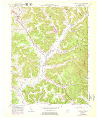
1951 Map of Plummers Landing
USGS Topo · Published 1979About this map
Plummers Landing and the surrounding Fleming County countryside appear in this survey, defined by a dense network of creek-bottom settlements and upland ridges like Peak Ridge. The landscape is dotted with local landmarks of genealogical interest, including the Shiloh Ch and Plummers Mill, reflecting a mid-century rural economy centered on small crossroads and water-powered history. The terrain transitions into the Flats toward the southeast, where the Daniel Boone National Forest begins to dominate the geography. Education and community life are marked by the presence of the Big Run Sch and Daulton Sch, while the scattered family burial grounds like Skinner Cem and Newman Cem provide specific points of reference for those tracing local family roots in this corner of Kentucky.
Find a feature on this map
69 named features on this map. Tap any name to fly to it.
Don’t see what you’re looking for? This feature index may not catch every label — zoom into the map to look around manually.
Map Details
Editions of this 1951 Plummers Landing Map
Other maps of this area

1929 · Morehead
USGS Topo · 1:48,000

1929 · Salt Lick
USGS Topo · 1:62,500

1934 · Salt Lick
USGS Topo · 1:62,500

1935 · Morehead
USGS Topo · 1:62,500

1951 · Cranston
USGS Topo · 1:24,000

1951 · Hillsboro
USGS Topo · 1:24,000

1951 · Stricklett
USGS Topo · 1:24,000

1951 · Plummers Landing
USGS Topo · 1:24,000

1951 · Burtonville
USGS Topo · 1:24,000

1951 · Flemingsburg
USGS Topo · 1:24,000