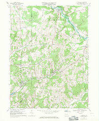
1968 Map of Plumville
USGS Topo · Published 1971About this map
The county border between Armstrong Co and Indiana Co runs through this Western Pennsylvania landscape, where rural life in the late 1960s was defined by winding creeks and a growing network of gas wells. The borough of Plumville sits at the junction of several local routes, while the mining settlement of Sagamore to the southwest highlights the region's industrial heritage with a nearby Strip Mine and proximity to the North Branch of Cowanshannock Creek. Genealogists will find significant value in the numerous religious landmarks clustered near Beyer, including Sacred Heart Cem, SS Peter and Paul Cem, and St Johns Cem. The northern landscape is dominated by the Little Mahoning Creek Reservoir and the village of Smicksburg, illustrating a transition from traditional agricultural patterns to the managed water systems of the era.
Find a feature on this map
38 named features on this map. Tap any name to fly to it.
Don’t see what you’re looking for? This feature index may not catch every label — zoom into the map to look around manually.
Map Details
Editions of this 1968 Plumville Map
Other maps of this area

1901 · Rural Valley
USGS Topo · 1:62,500

1902 · Indiana
USGS Topo · 1:62,500

1902 · Elders Ridge
USGS Topo · 1:62,500

1903 · Rural Valley
USGS Topo · 1:62,500

1904 · Elders Ridge
USGS Topo · 1:62,500

1909 · Smicksburg
USGS Topo · 1:62,500

1938 · Smicksburg
USGS Topo · 1:62,500

1939 · Smicksburg
USGS Topo · 1:62,500

1953 · Pittsburgh
USGS Topo · 1:250,000

1954 · Pittsburgh
USGS Topo · 1:250,000