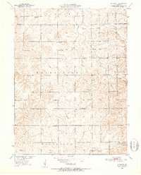
1950 Map of Plymouth
USGS Topo · Published 1952About this map
Plymouth serves as the central settlement in this rural landscape near the border of Livingston and Carroll Counties. The terrain is defined by its small-town infrastructure and educational history, featuring a dense network of country schools like Hazel Dell Sch and Lyon Sch alongside family-named sites. The land rises toward the northeast at Blue Mound, while the southern reaches are drained by Turkey Creek.
Find a feature on this map
30 named features on this map. Tap any name to fly to it.
Don’t see what you’re looking for? This feature index may not catch every label — zoom into the map to look around manually.
Map Details
Editions of this 1950 Plymouth Map
3 editions found
Other maps of this area

1889 · Lexington
USGS Topo · 1:125,000

1924 · Dawn
USGS Topo · 1:62,500

1924 · Braymer
USGS Topo · 1:62,500

1950 · Coloma
USGS Topo · 1:24,000

1950 · Plymouth
USGS Topo · 1:24,000

1951 · Utica
USGS Topo · 1:62,500

1953 · Moberly
USGS Topo · 1:250,000

1954 · Moberly
USGS Topo · 1:250,000

1957 · Moberly
USGS Topo · 1:250,000
1957 · Roads
USGS Topo · 1:24,000