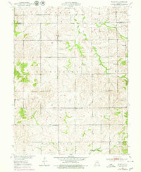
1950 Map of Plymouth
USGS Topo · Published 1979About this map
Plymouth and the surrounding rural townships of Carroll and Livingston counties are captured here during a period of transition in mid-century Missouri. The landscape is defined by its small-scale educational and spiritual hubs, with numerous country schools like Lyon Sch and Pleasant Valley Sch serving the local farming families. The settlement at Quote and the presence of Enoch Ch and Low Gap Ch illustrate the dispersed yet interconnected nature of rural life before the consolidation of rural services.
Find a feature on this map
23 named features on this map. Tap any name to fly to it.
Don’t see what you’re looking for? This feature index may not catch every label — zoom into the map to look around manually.
Map Details
Editions of this 1950 Plymouth Map
3 editions found
Other maps of this area

1889 · Lexington
USGS Topo · 1:125,000

1924 · Dawn
USGS Topo · 1:62,500

1924 · Braymer
USGS Topo · 1:62,500

1950 · Coloma
USGS Topo · 1:24,000

1950 · Plymouth
USGS Topo · 1:24,000

1951 · Utica
USGS Topo · 1:62,500

1953 · Moberly
USGS Topo · 1:250,000

1954 · Moberly
USGS Topo · 1:250,000

1957 · Moberly
USGS Topo · 1:250,000
1957 · Roads
USGS Topo · 1:24,000