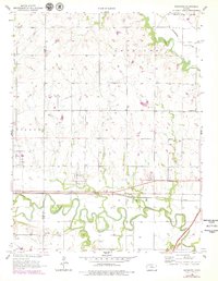
1957 Map of Plymouth
USGS Topo · Published 1979About this map
The Cottonwood River carves a winding path across this landscape, defining the agricultural and transit corridor between the settlements of Plymouth and Toledo. This 1957 survey, updated with late-1970s revisions, illustrates the established rural infrastructure of Lyon and Chase counties, where the Atchison Topeka and Santa Fe railroad and the Kansas Turnpike parallel the river's course. Local life is anchored by community landmarks such as Saffordville Ch, Cottonwood Ch, and several family and community burial grounds, including Hillside Cem and Hayworth Cem.
Find a feature on this map
31 named features on this map. Tap any name to fly to it.
Don’t see what you’re looking for? This feature index may not catch every label — zoom into the map to look around manually.
Map Details
Editions of this 1957 Plymouth Map
2 editions found
Other maps of this area

1885 · Eskridge
USGS Topo · 1:125,000

1888 · Emporia
USGS Topo · 1:125,000

1889 · Eskridge
USGS Topo · 1:125,000

1894 · Emporia
USGS Topo · 1:125,000

1894 · Eskridge
USGS Topo · 1:125,000

1955 · Hutchinson
USGS Topo · 1:250,000

1957 · Emporia
USGS Topo · 1:24,000

1957 · Saffordville
USGS Topo · 1:24,000

1957 · Plymouth
USGS Topo · 1:24,000

1959 · Hutchinson
USGS Topo · 1:250,000