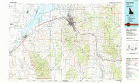
1984 Map of Pocatello
USGS Topo · Published 1984About this map
Pocatello and the neighboring settlements of Chubbuck and Tyhee serve as the urban anchor in this 1980s-era study, situated at the junction of the Portneuf River and the high desert plains. The influence of the Union Pacific railroad is evident in the rail corridors that snake through the valley, supporting a regional hub that includes Idaho State University and Mountain View Cem. To the north and west, the vast Fort Hall Indian Reservation encompasses Michaud Flats and stretches toward the American Falls Reservoir. The map reveals a landscape defined by significant elevation changes, from the Pocatello Range to the Caribou National Forest, where resource extraction is marked at sites like the Fort Hall Mine and Moonlight Mine. Downstream along the Snake River, recreational and historical sites such as Massacre Rocks State Park and Indian Rocks State Park sit alongside small communities like Neeley and American Falls.
Find a feature on this map
89 named features on this map. Tap any name to fly to it.
Don’t see what you’re looking for? This feature index may not catch every label — zoom into the map to look around manually.
Map Details
Editions of this 1984 Pocatello Map
2 editions found
Other maps of this area

1915 · Preston
USGS Topo · 1:96,000

1917 · Portneuf
USGS Topo · 1:62,500

1918 · Preston
USGS Topo · 1:125,000

1918 · Paradise Valley
USGS Topo · 1:62,500

1934 · American Falls
USGS Topo · 1:62,500

1934 · Michaud
USGS Topo · 1:62,500

1934 · Rockland
USGS Topo · 1:62,500

1936 · American Falls
USGS Topo · 1:62,500

1937 · Rockland
USGS Topo · 1:62,500

1937 · Pocatello
USGS Topo · 1:48,000