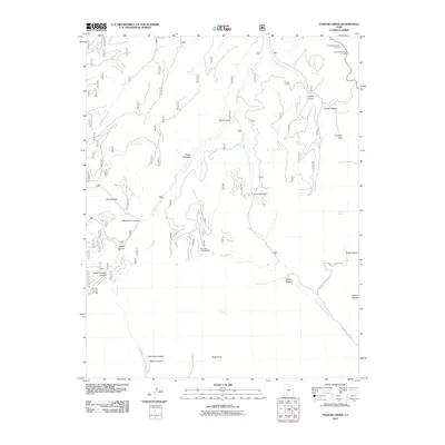
2011 Map of Podunk Creek
USGS Topo · Published 2011About this map
Pink Cliffs Viewing Area serves as a primary vantage point in this high-altitude landscape where the drainage networks of southern Utah's plateau country begin their descent. The map illustrates a complex system of canyon and hollow topography, defined by the headwaters of Podunk Creek and Crawford Creek. High points such as Ponderosa Canyon Overlook and Black Birch Canyon Overlook provide orientation along the rim, while deep cuts like Robinson Canyon and Swapp Canyon dominate the western portion of the quadrangle. This area is characterized by its hydrological transition, with moisture-gathering spots like Sieler Meadow and Coyote Spring feeding into the intricate branches of East Fork Creek and the Left Fork Upper Kanab Creek. The inclusion of Yovimpa Pass and Crawford Pass highlights the natural corridors used to navigate this broken terrain, where few established roads like Crawford Canyon Rd penetrate the interior.
Find a feature on this map
34 named features on this map. Tap any name to fly to it.
Don’t see what you’re looking for? This feature index may not catch every label — zoom into the map to look around manually.
Map Details
Editions of this 2011 Podunk Creek Map
This is the sole edition of this map. No revisions or reprints were ever made.
Other maps of this area

1886 · Kanab
USGS Topo · 1:250,000

1953 · Cedar City
USGS Topo · 1:250,000

1958 · Cedar City
USGS Topo · 1:250,000

1962 · Cedar City
USGS Topo · 1:250,000

1966 · Alton
USGS Topo · 1:24,000

1966 · Bald Knoll
USGS Topo · 1:24,000
1966 · Deer Spring Point
USGS Topo · 1:24,000

1966 · George Mtn
USGS Topo · 1:24,000
1966 · Podunk Creek
USGS Topo · 1:24,000
1966 · Skutumpah Creek
USGS Topo · 1:24,000