
1966 Map of Bald Knoll
USGS Topo · Published 1968About this map
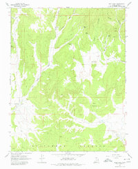
Skutumpah Terrace dominates the southern portion of this landscape, rising above a complex network of canyons and washes characteristic of this region in the mid-1960s. The prominent volcanic cinder cone of Bald Knoll serves as a central landmark, overlooking the surrounding drainage patterns where Sink Valley Wash and Kanab Creek have carved distinct paths through the terrain. Evidence of localized industry and resource extraction is visible through markings for several Mines and a Borrow Pit near The Falls. The map reveals a land defined by its water sources, with numerous named points such as Spaniard Spring, Echo Spring, and Fuller Spring that would have been vital for ranching and travel. A system of Jeep Trails provides the primary means of access through remote areas like Ford Pasture and Broad Hollow, illustrating the limited transportation infrastructure of the era.
Find a feature on this map
22 named features on this map. Tap any name to fly to it.
Don’t see what you’re looking for? This feature index may not catch every label — zoom into the map to look around manually.
Map Details
Editions of this 1966 Bald Knoll Map
2 editions found
Other maps of this area

1886 · Kanab
USGS Topo · 1:250,000

1953 · Cedar City
USGS Topo · 1:250,000

1954 · Johnson NE
USGS Topo · 1:24,000

1954 · Johnson
USGS Topo · 1:62,500

1957 · Kanab
USGS Topo · 1:62,500

1958 · Cedar City
USGS Topo · 1:250,000

1958 · Orderville
USGS Topo · 1:62,500

1962 · Cedar City
USGS Topo · 1:250,000

1966 · Alton
USGS Topo · 1:24,000
1966 · Podunk Creek
USGS Topo · 1:24,000