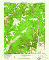
1957 Map of Kanab
USGS Topo · Published 1960About this map
Kanab serves as the primary hub in this late 1950s survey of southern Utah, situated where the high desert plateaus meet the Arizona border. The landscape is dominated by the intricate drainage systems of Kanab Creek and Muddy Creek, which carve through the Moquith Mountains and the stark elevations of Block Mesa. This era finds the region defined by a mix of ranching outposts like Foot Ranch and the nascent tourism and transit at Mt Carmel Junction.
Find a feature on this map
71 named features on this map. Tap any name to fly to it.
Don’t see what you’re looking for? This feature index may not catch every label — zoom into the map to look around manually.
Map Details
Editions of this 1957 Kanab Map
2 editions found

Other maps of this area

1886 · Kanab
USGS Topo · 1:250,000

1886 · Kaibab
USGS Topo · 1:250,000

1953 · Cedar City
USGS Topo · 1:250,000

1953 · Grand Canyon
USGS Topo · 1:250,000

1954 · Kanab SW
USGS Topo · 1:24,000

1954 · Orderville Canyon SE
USGS Topo · 1:24,000
1954 · Fredonia NW
USGS Topo · 1:24,000

1954 · Kanab SE
USGS Topo · 1:24,000

1954 · Shinarump NW
USGS Topo · 1:24,000

1954 · Johnson SW
USGS Topo · 1:24,000