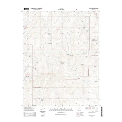
2014 Map of Podunk Creek
USGS Topo · Published 2014About this map
Paunsaugunt Plateau dominates this high-altitude landscape in Kane County, where the eastern boundary of the Dixie National Forest meets the western edge of Bryce Canyon National Park. The terrain is defined by dramatic geological breaks, most notably at the Sunset Cliffs and the Pink Cliffs, where the plateau drops away into a complex system of drainages. Headwaters for several significant waterways are found here, including Podunk Creek, Upper Kanab Creek, and Sieler Creek. The map reveals a land utilized for transit and seasonal grazing, evidenced by named locations like Sieler Meadow and Crawford Pass. From the high point at Yovimpa Pass to the depths of Mill Creek Canyon and Robinson Canyon, the survey illustrates the intricate network of hollows and ridges that characterize this portion of the Colorado Plateau.
Find a feature on this map
42 named features on this map. Tap any name to fly to it.
Don’t see what you’re looking for? This feature index may not catch every label — zoom into the map to look around manually.
Map Details
Editions of this 2014 Podunk Creek Map
This is the sole edition of this map. No revisions or reprints were ever made.
Other maps of this area

1886 · Kanab
USGS Topo · 1:250,000

1953 · Cedar City
USGS Topo · 1:250,000

1958 · Cedar City
USGS Topo · 1:250,000

1962 · Cedar City
USGS Topo · 1:250,000

1966 · Alton
USGS Topo · 1:24,000

1966 · Bald Knoll
USGS Topo · 1:24,000
1966 · Deer Spring Point
USGS Topo · 1:24,000

1966 · George Mtn
USGS Topo · 1:24,000
1966 · Podunk Creek
USGS Topo · 1:24,000
1966 · Skutumpah Creek
USGS Topo · 1:24,000