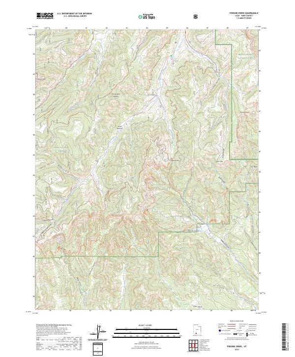
2023 Map of Podunk Creek
USGS Topo · Published 2023About this map
Paunsaugunt Plateau dominates this high-altitude landscape where the borders of several major public lands meet. This modern survey illustrates the complex topography of southern Utah, where the elevated heights of the plateau drop away at Sunset Cliffs and the prominent Pink Cliffs. The map details a network of canyons and drainage systems, including Podunk Creek and the headwaters of the East Fork Creek. These drainages have historically shaped the routes of travel through the region, now preserved as trails such as the Great Western Trl and Mill Creek Trl. The intersection of Bryce Canyon National Park, the Dixie National Forest, and Grand Staircase-Escalante National Monument highlights the area's significance as a protected wilderness, defined by high-elevation meadows like Sieler Meadow and critical mountain crossings such as Yovimpa Pass.
Find a feature on this map
45 named features on this map. Tap any name to fly to it.
Don’t see what you’re looking for? This feature index may not catch every label — zoom into the map to look around manually.
Map Details
Editions of this 2023 Podunk Creek Map
This is the sole edition of this map. No revisions or reprints were ever made.
Other maps of this area

1886 · Kanab
USGS Topo · 1:250,000

1953 · Cedar City
USGS Topo · 1:250,000

1958 · Cedar City
USGS Topo · 1:250,000

1962 · Cedar City
USGS Topo · 1:250,000

1966 · Alton
USGS Topo · 1:24,000

1966 · Bald Knoll
USGS Topo · 1:24,000
1966 · Deer Spring Point
USGS Topo · 1:24,000

1966 · George Mtn
USGS Topo · 1:24,000
1966 · Podunk Creek
USGS Topo · 1:24,000
1966 · Skutumpah Creek
USGS Topo · 1:24,000