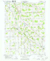
1962 Map of Poe
USGS Topo · Published 1963About this map
The St Marys River meanders through the heart of Allen County, anchoring a landscape defined by small rural hubs and a complex network of drainage ditches. This survey captures the mid-century character of Hessen Cassel and Poe, where family names are etched into the infrastructure via landmarks like Muldoon Bridge and Scheiman Bridge. The land use transition is evident in the inclusion of Traver Court, while the enduring presence of local heritage is marked by a high density of country burial grounds and schoolhouses, including Antioch Cem, Bethel Cem, and Emmanuel Sch. From the Gaging Sta on the river to the Radio Facility near Yoder Road, the map illustrates a community balanced between its agricultural roots and modern technological installations.
Find a feature on this map
41 named features on this map. Tap any name to fly to it.
Don’t see what you’re looking for? This feature index may not catch every label — zoom into the map to look around manually.
Map Details
Editions of this 1962 Poe Map
4 editions found
Other maps of this area

1953 · Fort Wayne
USGS Topo · 1:250,000

1953 · Muncie
USGS Topo · 1:250,000

1956 · Muncie
USGS Topo · 1:250,000

1956 · Fort Wayne
USGS Topo · 1:250,000

1956 · Fort Wayne West
USGS Topo · 1:24,000

1956 · Fort Wayne East
USGS Topo · 1:24,000

1957 · Maples
USGS Topo · 1:24,000

1961 · Hoagland
USGS Topo · 1:24,000

1962 · Poe
USGS Topo · 1:24,000

1962 · Uniondale
USGS Topo · 1:24,000