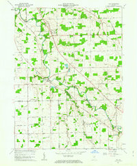
1962 Map of Poe
USGS Topo · Published 1979About this map
The St Marys River meanders across this rural landscape south of Fort Wayne, defining the settlement patterns and road networks of early 1960s Allen County. The village of Poe sits at a prominent bend in the river, connected to the surrounding countryside by a dense grid of gravel and paved roads like Winchester Road. To the north, the community of Hessen Cassel serves as a local hub, while the Erie Railroad cuts a diagonal path through the eastern section near Hoagland. This era shows a high concentration of institutional landmarks that tell the story of the area's social fabric, including Emmanuel Sch, Antioch Ch, and multiple family or parish burial grounds such as Archbold Cem and El Honan Cem. The intersection of drainage ditches like Nickelsen Ditch with traditional routes like Wayne Trace illustrates the ongoing agricultural management of this Indiana flatland.
Find a feature on this map
65 named features on this map. Tap any name to fly to it.
Don’t see what you’re looking for? This feature index may not catch every label — zoom into the map to look around manually.
Map Details
Editions of this 1962 Poe Map
4 editions found
Other maps of this area

1953 · Fort Wayne
USGS Topo · 1:250,000

1953 · Muncie
USGS Topo · 1:250,000

1956 · Muncie
USGS Topo · 1:250,000

1956 · Fort Wayne
USGS Topo · 1:250,000

1956 · Fort Wayne West
USGS Topo · 1:24,000

1956 · Fort Wayne East
USGS Topo · 1:24,000

1957 · Maples
USGS Topo · 1:24,000

1961 · Hoagland
USGS Topo · 1:24,000

1962 · Poe
USGS Topo · 1:24,000

1962 · Uniondale
USGS Topo · 1:24,000