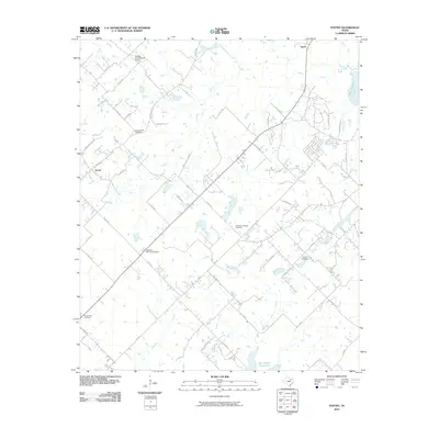
2010 Map of Poetry
USGS Topo · Published 2010About this map
Poetry and the surrounding Hunt County countryside appear here in a period of rural character punctuated by established family burial grounds and small-scale aviation. The landscape is defined by the South Fork Sabine River and its tributaries, including Greasy Creek and Walnut Creek. Cultural history is anchored by numerous cemeteries such as Campground Cemetery, Henderson Mosley Cemetery, and Weaver Cemetery, which serve as vital points for genealogical research in this part of Texas. In the south, the New Terrell City Lake provides a significant water feature, while the northern reaches include the Phillips Flying Ranch Airport. The map also captures the northeastern edge of Lake Tawakoni Kitsee Inlet, showing how the local road network, including the curiously named Hanging Tree Rd, navigates the rolling terrain between these drainages.
Find a feature on this map
56 named features on this map. Tap any name to fly to it.
Don’t see what you’re looking for? This feature index may not catch every label — zoom into the map to look around manually.
Map Details
Editions of this 2010 Poetry Map
This is the sole edition of this map. No revisions or reprints were ever made.
Other maps of this area

1919 · Royse City
USGS Topo · 1:62,500

1954 · Dallas
USGS Topo · 1:250,000

1956 · Kaufman
USGS Topo · 1:62,500

1956 · Quinlan
USGS Topo · 1:62,500

1958 · Dallas
USGS Topo · 1:250,000

1962 · Elmo
USGS Topo · 1:24,000

1962 · Wills Point
USGS Topo · 1:24,000
1962 · Terrell North
USGS Topo · 1:24,000
1963 · Terrell South
USGS Topo · 1:24,000
1963 · Royse City
USGS Topo · 1:24,000