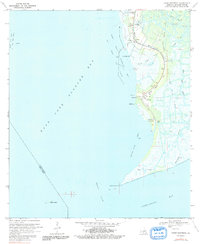
1970 Map of Point Chevreuil
USGS Topo · Published 1991About this map
The coastal marshes and waterways of St. Mary Parish define this 1970 landscape, where the land transitions into the expansive East Cote Blanche Bay. This survey captures a region dominated by the extraction industry, specifically the Bayou Sale Oil and Gas Field and the East Cote Blanche Bay Oil and Gas Field, which are marked by numerous platforms and pipelines cutting through the wetlands. Small coastal outposts such as South Bend, Gordy, and Burns are linked by Route 317, serving as the primary land-based connections in an area otherwise governed by water.
Find a feature on this map
27 named features on this map. Tap any name to fly to it.
Don’t see what you’re looking for? This feature index may not catch every label — zoom into the map to look around manually.
Map Details
Editions of this 1970 Point Chevreuil Map
3 editions found
Other maps of this area

1935 · Belle Isle
USGS Topo · 1:31,680

1937 · Bayou Sale
USGS Topo · 1:62,500

1941 · Belle Isle
USGS Topo · 1:62,500

1945 · New Orleans
USGS Topo · 1:250,000
1951 · Lake Point
USGS Topo · 1:24,000

1954 · Belle Isle
USGS Topo · 1:62,500

1957 · Bayou Sale
USGS Topo · 1:62,500

1957 · Point Au Fer
USGS Topo · 1:62,500

1963 · New Orleans
USGS Topo · 1:250,000

1966 · New Orleans
USGS Topo · 1:250,000