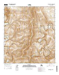
2014 Map of Point Hope A-1 NE
USGS Topo · Published 2014About this map
Sakolik Mountain rises as the dominant landform in this remote Arctic landscape, anchoring the northwestern corner of the quadrangle. The Kukpuk River defines the physical geography here, its winding course carving deep, serpentine meanders through the coastal tundra. The river's path is characterized by sharp oxbow bends and steep bank incisions, reflecting a complex hydrologic history of seasonal runoff and shifts in the permafrost-laden terrain. Mapping of this area relies heavily on township and range boundaries such as t33n r28w and t32n r28w, which provide the only structural grid for navigation in a region devoid of permanent settlements, roads, or named man-made structures. The landscape remains an untouched expanse of the North Slope, where the drainage patterns of the Kukpuk River provide the primary orientation for those traversing the Alaskan wilderness.
Find a feature on this map
7 named features on this map. Tap any name to fly to it.
Don’t see what you’re looking for? This feature index may not catch every label — zoom into the map to look around manually.
Map Details
Editions of this 2014 Point Hope A-1 NE Map
This is the sole edition of this map. No revisions or reprints were ever made.
Other maps of this area

1951 · De Long Mountains
USGS Topo · 1:250,000

1952 · Point Hope
USGS Topo · 1:250,000

1955 · De Long Mountains
USGS Topo · 1:250,000

1955 · Point Hope
USGS Topo · 1:250,000

1955 · Point Hope A-1
USGS Topo · 1:63,360

1955 · Point Hope B-1
USGS Topo · 1:63,360
1955 · De Long Mountains A-5
USGS Topo · 1:63,360
1955 · De Long Mountains B-5
USGS Topo · 1:63,360

1965 · Point Hope
USGS Topo · 1:250,000

1965 · De Long Mountains
USGS Topo · 1:250,000