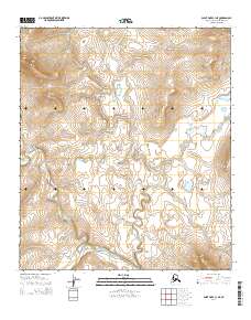
2014 Map of Point Hope C-1 NE
USGS Topo · Published 2014About this map
Nilik River meanders through this portion of the North Slope, defining a landscape dominated by the intricate hydrology of the Alaska tundra. The drainage patterns of Sakvelak Cr and Oligavik Cr illustrate the complex network of seasonal and perennial waterways that characterize the region. In the southwestern corner, Kekiktalik Lake serves as a prominent landmark within this open expanse. The presence of South Aluk Hill provides one of the few significant topographic elevations on the sheet, offering a distinct contrast to the surrounding low-lying plains. This 2014 survey captures the area within the North Slope Borough, documented by the U.S. Geological Survey at a time when mapping of remote Alaskan terrain reached new levels of digital precision through the National Geospatial Program.
Find a feature on this map
10 named features on this map. Tap any name to fly to it.
Don’t see what you’re looking for? This feature index may not catch every label — zoom into the map to look around manually.
Map Details
Editions of this 2014 Point Hope C-1 NE Map
This is the sole edition of this map. No revisions or reprints were ever made.
Other maps of this area

1951 · De Long Mountains
USGS Topo · 1:250,000

1952 · Point Hope
USGS Topo · 1:250,000

1952 · Point Hope D-1
USGS Topo · 1:63,360

1955 · De Long Mountains
USGS Topo · 1:250,000

1955 · Point Hope
USGS Topo · 1:250,000

1955 · Point Hope C-1
USGS Topo · 1:63,360

1955 · De Long Mountains C-5
USGS Topo · 1:63,360
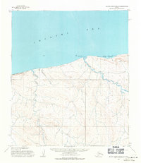
1955 · De Long Mountains D-5
USGS Topo · 1:63,360

1965 · Point Hope
USGS Topo · 1:250,000

1965 · De Long Mountains
USGS Topo · 1:250,000