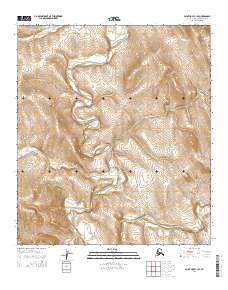
2014 Map of Point Hope C-1 SE
USGS Topo · Published 2014About this map
The Nilik River meanders through this portion of the North Slope, serving as a central drainage point for the surrounding highlands. This 2014 survey reveals a landscape defined by its complex hydrology, where the Ipewik River and smaller tributaries like Uyakturok Cr carve through the terrain. The topography is anchored by prominent rises such as Tungnak Hill in the northwest and Amulik Hill to the northeast, which provide significant elevation above the river valleys.
Find a feature on this map
13 named features on this map. Tap any name to fly to it.
Don’t see what you’re looking for? This feature index may not catch every label — zoom into the map to look around manually.
Map Details
Editions of this 2014 Point Hope C-1 SE Map
This is the sole edition of this map. No revisions or reprints were ever made.
Other maps of this area

1951 · De Long Mountains
USGS Topo · 1:250,000

1952 · Point Hope
USGS Topo · 1:250,000

1955 · De Long Mountains
USGS Topo · 1:250,000

1955 · Point Hope
USGS Topo · 1:250,000

1955 · Point Hope C-1
USGS Topo · 1:63,360

1955 · Point Hope B-1
USGS Topo · 1:63,360

1955 · De Long Mountains C-5
USGS Topo · 1:63,360
1955 · De Long Mountains B-5
USGS Topo · 1:63,360

1965 · Point Hope
USGS Topo · 1:250,000

1965 · De Long Mountains
USGS Topo · 1:250,000