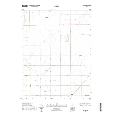
2019 Map of Point Isabel
USGS Topo · Published 2019About this map
Swayzee and Point Isabel anchor this agricultural landscape in central Indiana, where the grid of rural roads crosses a complex network of waterways. The terrain is defined by its drainage history, featuring numerous engineered channels such as Wimmer Ditch, Keaton Ditch, and Pattison Ditch that support the surrounding farmstead plots. These ditches feed into natural meandering streams like Pipe Cr and Wildcat Cr. Smaller settlements like Normal and Cole punctuate the intersections of Grant County, while the southern edge touches the boundary with Madison and Tipton Counties. Genealogists may find interest in the Alel Cem located near the eastern border, while the preservation of traditional place names like Rigdon and Poley Walk provides a glimpse into the local nomenclature of the region.
Find a feature on this map
65 named features on this map. Tap any name to fly to it.
Don’t see what you’re looking for? This feature index may not catch every label — zoom into the map to look around manually.
Map Details
Editions of this 2019 Point Isabel Map
This is the sole edition of this map. No revisions or reprints were ever made.
Other maps of this area

1953 · Muncie
USGS Topo · 1:250,000

1956 · Muncie
USGS Topo · 1:250,000

1960 · Elwood
USGS Topo · 1:24,000

1960 · Point Isabel
USGS Topo · 1:24,000

1960 · Alexandria
USGS Topo · 1:24,000

1960 · Fairmount
USGS Topo · 1:24,000

1960 · Windfall
USGS Topo · 1:24,000

1960 · Greentown
USGS Topo · 1:24,000

1961 · Marion
USGS Topo · 1:24,000
1962 · Amboy
USGS Topo · 1:24,000