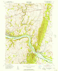
1955 Map of Point Of Rocks
USGS Topo · Published 1956About this map
Point of Rocks serves as a focal point where the Baltimore and Ohio railroad meets the Potomac River and the historic Chesapeake and Ohio Canal. This mid-1950s landscape reveals the enduring transportation corridor through the gap in Catoctin Mountain. To the north, the terrain transitions into the agricultural uplands of Frederick County, dotted with rural centers like Jefferson and Petersville. The river is characterized by significant landforms including Heaters Island and Paton Island, with Furnace Mountain rising abruptly on the Virginia side. Local genealogy is well-supported by the presence of numerous country churches such as St Marks Ch and St Pauls Ch, alongside smaller settlements like Slabtown and Olive. The map preserves the location of Catoctin Sta (Lander PO), highlighting the historic post offices that once served these rail-side communities.
Find a feature on this map
52 named features on this map. Tap any name to fly to it.
Don’t see what you’re looking for? This feature index may not catch every label — zoom into the map to look around manually.
Map Details
Editions of this 1955 Point Of Rocks Map
2 editions found
Other maps of this area

1884 · Harpers Ferry
USGS Topo · 1:125,000

1891 · Harpers Ferry
USGS Topo · 1:125,000

1893 · Frederick
USGS Topo · 1:125,000

1893 · Harpers Ferry
USGS Topo · 1:125,000

1894 · Frederick
USGS Topo · 1:125,000

1908 · Middletown
USGS Topo · 1:48,000

1908 · Seneca
USGS Topo · 1:62,500

1908 · Ijamsville
USGS Topo · 1:62,500

1909 · Ijamsville
USGS Topo · 1:62,500

1910 · Antietam
USGS Topo · 1:62,500