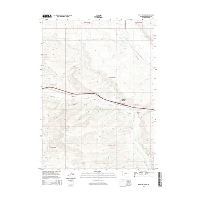
2015 Map of Point of Rocks
USGS Topo · Published 2015About this map
Point of Rocks serves as a focal point in this high-desert landscape of Sweetwater County, where modern infrastructure follows ancient routes. The path of the Overland Trl cuts across the terrain, a reminder of the westward migration through Wyoming that preceded the interstate and industrial development. This 2015 survey illustrates how the area's hydrology and human activity are closely linked, with the Jim Bridger Reservoir and Bitter Cr providing essential water resources in a region characterized by dramatic landforms like Shiprock and Coon Draw.
Find a feature on this map
16 named features on this map. Tap any name to fly to it.
Don’t see what you’re looking for? This feature index may not catch every label — zoom into the map to look around manually.
Map Details
Editions of this 2015 Point of Rocks Map
This is the sole edition of this map. No revisions or reprints were ever made.
Other maps of this area

1954 · Rock Springs
USGS Topo · 1:250,000

1958 · Rock Springs
USGS Topo · 1:250,000

1958 · Twelvemile Well
USGS Topo · 1:62,500

1958 · Superior
USGS Topo · 1:62,500

1962 · Rock Springs
USGS Topo · 1:250,000

1968 · Bitter Creek NW
USGS Topo · 1:24,000

1968 · Point Of Rocks SW
USGS Topo · 1:24,000

1968 · Black Buttes
USGS Topo · 1:24,000

1968 · Point Of Rocks
USGS Topo · 1:24,000
1968 · Point Of Rocks SE
USGS Topo · 1:24,000