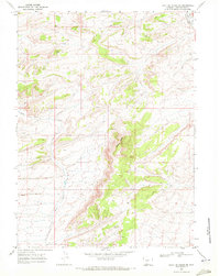
1968 Map of Point Of Rocks SE
USGS Topo · Published 1972About this map
The historical Overland Trail cuts across the northeastern corner of this landscape, following the path of the Union Pacific railroad alongside Bitter Creek. This 1968 survey reveals a terrain defined by the prominent Black Buttes ridge and the drainage of Black Butte Creek. The map documents the early stages of resource exploration in this part of Sweetwater County, with numerous labels for Drill Holes and Prospects scattered across the ridgelines and draws. These survey marks point to a transition in land use, where the legacy of nineteenth-century western migration routes meets the mid-twentieth-century industrial interest in the area's mineral potential.
Find a feature on this map
10 named features on this map. Tap any name to fly to it.
Don’t see what you’re looking for? This feature index may not catch every label — zoom into the map to look around manually.
Map Details
Editions of this 1968 Point Of Rocks SE Map
This is the sole edition of this map. No revisions or reprints were ever made.
Other maps of this area

1954 · Rock Springs
USGS Topo · 1:250,000

1958 · Rock Springs
USGS Topo · 1:250,000

1962 · Rock Springs
USGS Topo · 1:250,000

1968 · Cooper Ridge NE
USGS Topo · 1:24,000

1968 · Bitter Creek NW
USGS Topo · 1:24,000

1968 · Point Of Rocks SW
USGS Topo · 1:24,000

1968 · Sand Butte Rim NW
USGS Topo · 1:24,000

1968 · Black Buttes
USGS Topo · 1:24,000

1968 · Point Of Rocks
USGS Topo · 1:24,000

1968 · Camel Rock
USGS Topo · 1:24,000