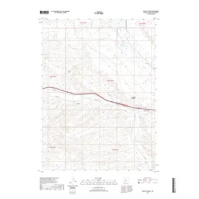
2017 Map of Point of Rocks
USGS Topo · Published 2017About this map
Point of Rocks serves as a central landmark in this high-desert portion of Sweetwater County, where modern infrastructure meets historic western pathways. The landscape is defined by the winding course of Bitter Cr and the presence of the Jim Bridger Reservoir to the north. A significant historical element is the Overland Trl, which traces a path through the territory south of the modern interstate corridor, following the natural contours near Shiprock. The terrain is characterized by sharp draws and washes, including Coon Draw and Deadman Wash, illustrating the drainage patterns that have shaped the region. Several access routes, such as Nine Mile Rd and various service roads, connect the isolated geographic features and industrial reservoir to the settlement at the rocky point.
Find a feature on this map
20 named features on this map. Tap any name to fly to it.
Don’t see what you’re looking for? This feature index may not catch every label — zoom into the map to look around manually.
Map Details
Editions of this 2017 Point of Rocks Map
This is the sole edition of this map. No revisions or reprints were ever made.
Other maps of this area

1954 · Rock Springs
USGS Topo · 1:250,000

1958 · Rock Springs
USGS Topo · 1:250,000

1958 · Twelvemile Well
USGS Topo · 1:62,500

1958 · Superior
USGS Topo · 1:62,500

1962 · Rock Springs
USGS Topo · 1:250,000

1968 · Bitter Creek NW
USGS Topo · 1:24,000

1968 · Point Of Rocks SW
USGS Topo · 1:24,000

1968 · Black Buttes
USGS Topo · 1:24,000

1968 · Point Of Rocks
USGS Topo · 1:24,000
1968 · Point Of Rocks SE
USGS Topo · 1:24,000