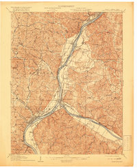
1908 Map of Point Pleasant
USGS Topo · Published 1919About this map
Point Pleasant serves as the focal point of this early 20th-century landscape, situated at the strategic confluence where the Kanawha River meets the Ohio River. The map reveals a densely settled river corridor defined by the Ohio River Div and the Kanawha and Michigan railroads, which facilitated the movement of goods between river towns like Henderson, Gallipolis, and Middleport. Beyond the floodplains, the terrain is deeply dissected by numerous creeks, including Ninemile Creek and Oldtown Creek, where small rural communities and institutions like Hickory Chapel and the Mission Ridge School took root.
Find a feature on this map
81 named features on this map. Tap any name to fly to it.
Don’t see what you’re looking for? This feature index may not catch every label — zoom into the map to look around manually.
Map Details
Editions of this 1908 Point Pleasant Map
3 editions found

Other maps of this area

1905 · Wilkesville
USGS Topo · 1:62,500

1906 · Bidwell
USGS Topo · 1:62,500

1906 · Athalia
USGS Topo · 1:62,500

1906 · Glenwood
USGS Topo · 1:62,500

1906 · Winfield
USGS Topo · 1:62,500

1907 · Pomeroy
USGS Topo · 1:62,500

1907 · Keno
USGS Topo · 1:62,500

1908 · Bidwell
USGS Topo · 1:62,500

1908 · Athalia
USGS Topo · 1:62,500

1908 · Glenwood
USGS Topo · 1:62,500