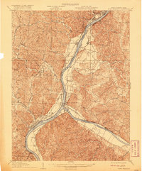
1908 Map of Point Pleasant
USGS Topo · Published 1920About this map
Point Pleasant and Gallipolis stand as the primary urban centers in this early 20th-century survey of the river confluence where the Kanawha River meets the Ohio River. The landscape is dominated by the strategic intersection of water and rail, with the Baltimore and Ohio RR and Kanawha and Michigan RR following the riverbanks to serve industrial and agricultural outposts like West Columbia, Spilman, and Middleport. This era shows a densely settled rural corridor punctuated by localized hubs such as Locust Lane Heights PO and several educational landmarks including Mission Ridge School and Fairview School. The map records a time when ferry crossings still bridged the state line between West Virginia and Ohio, linking settlements like Kanauga and Henderson before the widespread construction of modern highway bridges.
Find a feature on this map
73 named features on this map. Tap any name to fly to it.
Don’t see what you’re looking for? This feature index may not catch every label — zoom into the map to look around manually.
Map Details
Editions of this 1908 Point Pleasant Map
3 editions found

Other maps of this area

1905 · Wilkesville
USGS Topo · 1:62,500

1906 · Bidwell
USGS Topo · 1:62,500

1906 · Athalia
USGS Topo · 1:62,500

1906 · Glenwood
USGS Topo · 1:62,500

1906 · Winfield
USGS Topo · 1:62,500

1907 · Pomeroy
USGS Topo · 1:62,500

1907 · Keno
USGS Topo · 1:62,500

1908 · Bidwell
USGS Topo · 1:62,500

1908 · Athalia
USGS Topo · 1:62,500

1908 · Glenwood
USGS Topo · 1:62,500