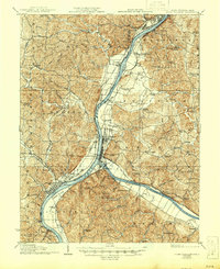
1929 Map of Point Pleasant
USGS Topo · Published 1946About this map
The confluence of the Ohio River and Kanawha River serves as the industrial and transport hub of this 1920s river valley study. At the center of the sheet, Point Pleasant sits where these two massive waterways meet, supported by the Baltimore and Ohio and New York Central rail lines. Across the water, the settlement of Gallipolis and the landing at Gallipolis Ferry illustrate the interconnected commerce between the West Virginia and Ohio banks before modern highway infrastructure superseded river transit.
Find a feature on this map
102 named features on this map. Tap any name to fly to it.
Don’t see what you’re looking for? This feature index may not catch every label — zoom into the map to look around manually.
Map Details
Editions of this 1929 Point Pleasant Map
2 editions found

Other maps of this area

1905 · Wilkesville
USGS Topo · 1:62,500

1906 · Bidwell
USGS Topo · 1:62,500

1906 · Athalia
USGS Topo · 1:62,500

1906 · Glenwood
USGS Topo · 1:62,500

1906 · Winfield
USGS Topo · 1:62,500

1907 · Pomeroy
USGS Topo · 1:62,500

1907 · Keno
USGS Topo · 1:62,500

1908 · Bidwell
USGS Topo · 1:62,500

1908 · Athalia
USGS Topo · 1:62,500

1908 · Glenwood
USGS Topo · 1:62,500