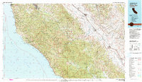
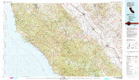
1982 Map of Point Sur
USGS Topo · Published 1982About this map
The Santa Lucia Range and the Sierra de Salinas dominate this coastal section of California, illustrating the dramatic transition from the high peaks of the Ventana Wilderness to the agricultural expanses of the Salinas River valley. The map documents the early 1980s landscape, featuring a mix of federal and state lands including the Fort Hunter Liggett Military Reservation and Pinnacles National Monument. Along the shoreline, the Pacific Ocean meets landmarks such as the Point Sur Lighthouse and Andrew Molera State Park, while State Hwy 1 provides the primary coastal artery.
Find a feature on this map
80 named features on this map. Tap any name to fly to it.
Don’t see what you’re looking for? This feature index may not catch every label — zoom into the map to look around manually.
Map Details
Editions of this 1982 Point Sur Map
3 editions found

Other maps of this area

1910 · Gonzales
USGS Topo · 1:31,680

1910 · Salinas
USGS Topo · 1:31,680

1910 · Soledad
USGS Topo · 1:31,680

1912 · Salinas
USGS Topo · 1:62,500

1912 · San Ardo
USGS Topo · 1:31,680

1912 · Metz
USGS Topo · 1:31,680

1913 · Monterey
USGS Topo · 1:62,500

1913 · Panoche
USGS Topo · 1:125,000

1915 · Soledad
USGS Topo · 1:62,500

1915 · Priest Valley
USGS Topo · 1:125,000