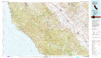
1982 Map of Point Sur
USGS Topo · Published 1980About this map
The Santa Lucia Range dominates this Central Coast landscape, separating the wild Pacific shoreline from the agricultural heart of the Salinas Valley. In the early 1980s, this region remained a patchwork of protected wilderness and specialized development, from the Sea Otter Game Refuge along the coast to the Fort Hunter Liggett Military Reservation in the south. The Southern Pacific railroad corridor serves as the backbone for valley floor settlements like King City, Soledad, and San Lucas, while the Cabrillo Highway clings to the cliffs near Point Sur and Pfeiffer Big Sur State Park. Interior landmarks such as Tassajara Hot Springs and the Soledad State Prison highlight the diverse land use, while the San Andreas Rift Zone traces the eastern edge through the Gabilan Range and Pinnacles National Monument.
Find a feature on this map
81 named features on this map. Tap any name to fly to it.
Don’t see what you’re looking for? This feature index may not catch every label — zoom into the map to look around manually.
Map Details
Editions of this 1982 Point Sur Map
3 editions found
Other maps of this area

1910 · Gonzales
USGS Topo · 1:31,680

1910 · Salinas
USGS Topo · 1:31,680

1910 · Soledad
USGS Topo · 1:31,680

1912 · Salinas
USGS Topo · 1:62,500

1912 · San Ardo
USGS Topo · 1:31,680

1912 · Metz
USGS Topo · 1:31,680

1913 · Monterey
USGS Topo · 1:62,500

1913 · Panoche
USGS Topo · 1:125,000

1915 · Soledad
USGS Topo · 1:62,500

1915 · Priest Valley
USGS Topo · 1:125,000