
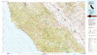
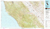
1982 Map of Point Sur
USGS Topo · Published 1982About this map
The Santa Lucia Range dominates this Central Coast landscape, rising sharply from the Pacific to meet the Sierra de Salinas and the Salinas River valley. This 1980s-era topographic study highlights the dramatic transition from the rocky coastline at Point Sur to the inland agricultural corridor. Along the coast, the Point Sur Lighthouse stands as a sentinel near the Sea Otter Game Refuge, while the interior shows the extensive holdings of the Fort Hunter Liggett Military Reservation and the Ventana Wilderness.
Find a feature on this map
84 named features on this map. Tap any name to fly to it.
Don’t see what you’re looking for? This feature index may not catch every label — zoom into the map to look around manually.
Map Details
Editions of this 1982 Point Sur Map
3 editions found
Other maps of this area

1910 · Gonzales
USGS Topo · 1:31,680

1910 · Salinas
USGS Topo · 1:31,680

1910 · Soledad
USGS Topo · 1:31,680

1912 · Salinas
USGS Topo · 1:62,500

1912 · San Ardo
USGS Topo · 1:31,680

1912 · Metz
USGS Topo · 1:31,680

1913 · Monterey
USGS Topo · 1:62,500

1913 · Panoche
USGS Topo · 1:125,000

1915 · Soledad
USGS Topo · 1:62,500

1915 · Priest Valley
USGS Topo · 1:125,000