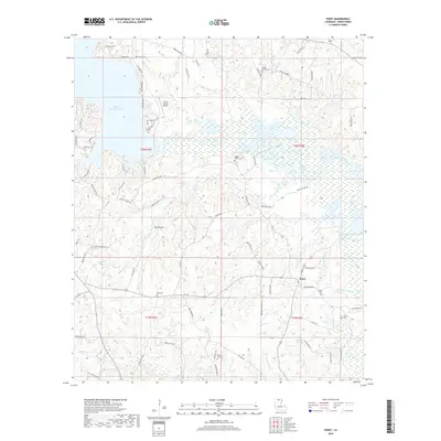
2018 Map of Point
USGS Topo · Published 2018About this map
Bayou D'Arbonne Lake and its intricate network of wetlands dominate the landscape of central Union Parish, where the winding Bayou D'Arbonne feeds into a complex system of sloughs and creeks. The settlement of Point serves as a local hub south of the water, connected by a network of rural routes like Moseleys Bluff Rd and Spillway Rd. The presence of the Union Parish Airport north of the lake reflects the modern infrastructure integrated into this traditionally riverine environment. For those researching local history, the map identifies numerous small family and community burial grounds, including Ruggs Bluff Cem, King Cem, and Acree Cem, which are scattered among the timbered slopes and creek bottoms of the t20n r1e and t20n r2e townships. This 2018 survey provides an exceptionally detailed view of the water boundaries, including Francis Cr Lake and Lake Drain Slough, illustrating how the hydrology shapes the local road and settlement patterns.
Find a feature on this map
86 named features on this map. Tap any name to fly to it.
Don’t see what you’re looking for? This feature index may not catch every label — zoom into the map to look around manually.
Map Details
Editions of this 2018 Point Map
This is the sole edition of this map. No revisions or reprints were ever made.
Other maps of this area

1935 · Drew
USGS Topo · 1:62,500

1935 · Haile
USGS Topo · 1:62,500

1952 · Calhoun
USGS Topo · 1:62,500

1952 · Farmerville
USGS Topo · 1:62,500

1955 · Shreveport
USGS Topo · 1:250,000

1956 · Shreveport
USGS Topo · 1:250,000

1956 · Haile
USGS Topo · 1:62,500

1957 · Monroe North
USGS Topo · 1:62,500

1957 · West Monroe North
USGS Topo · 1:24,000
1969 · Monroe North
USGS Topo · 1:62,500