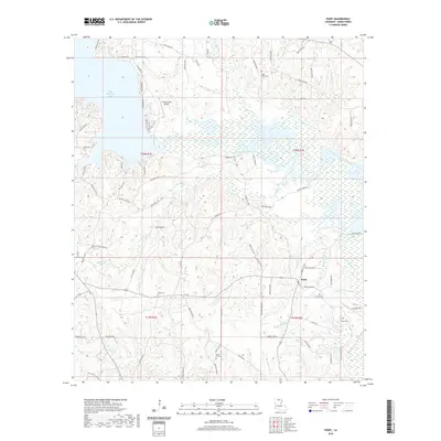
2020 Map of Point
USGS Topo · Published 2020About this map
The community of Point sits at the center of this Union Parish landscape, where the headwaters of numerous creeks feed into the expansive Bayou D'Arbonne Lake. The terrain is characterized by its drainage network, with Tiger Cr, Horse-Pen Cr, and Briny Bridge Cr winding through the countryside. This modern survey illustrates the persistent rural character of the area, punctuated by a significant concentration of family and community burial grounds, including Ruggs Bluff Cem, King Cem, and Morse Hill Cem. The presence of the Union Parish Airport north of the lake contrasts with the traditional settlement patterns found at Moseleys Bluff and Ruggs Bluff, showing how local infrastructure has adapted to the region's topography and water systems over time.
Find a feature on this map
89 named features on this map. Tap any name to fly to it.
Don’t see what you’re looking for? This feature index may not catch every label — zoom into the map to look around manually.
Map Details
Editions of this 2020 Point Map
This is the sole edition of this map. No revisions or reprints were ever made.
Other maps of this area

1935 · Drew
USGS Topo · 1:62,500

1935 · Haile
USGS Topo · 1:62,500

1952 · Calhoun
USGS Topo · 1:62,500

1952 · Farmerville
USGS Topo · 1:62,500

1955 · Shreveport
USGS Topo · 1:250,000

1956 · Shreveport
USGS Topo · 1:250,000

1956 · Haile
USGS Topo · 1:62,500

1957 · Monroe North
USGS Topo · 1:62,500

1957 · West Monroe North
USGS Topo · 1:24,000
1969 · Monroe North
USGS Topo · 1:62,500