
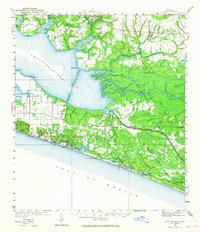
1936 Map of Point Washington
USGS Topo · Published 1936About this map
Choctawhatchee Bay dominates this coastal survey, where the intricate transition from salt water to the delta of the Choctawhatchee River is documented through numerous islands and bayous. In the mid-1930s, the community of Point Washington served as a key hub near the Pt. Washington Light House, which guided maritime traffic navigating from the Gulf of Mexico toward the sheltered interior bays. The map records a landscape of coastal lakes and marshy river channels, including Duck Lake and Cypress Lake, alongside small islands like Nancys Island and Williams Island. Further inland, the settlement pattern centers around Freeport and the Bunker Ch and Bunker Cem, providing valuable evidence of local social geography for genealogists. The shoreline near Grayton and Seagrove Beach shows a sparsely developed coast characterized by dune-locked waters like Camp Creek Lake.
Find a feature on this map
38 named features on this map. Tap any name to fly to it.
Don’t see what you’re looking for? This feature index may not catch every label — zoom into the map to look around manually.
Map Details
Editions of this 1936 Point Washington Map
2 editions found
Other maps of this area

1934 · Niceville
USGS Topo · 1:48,000

1935 · Villa Tasso
USGS Topo · 1:48,000

1935 · De Funiak Springs
USGS Topo · 1:48,000

1936 · Niceville
USGS Topo · 1:62,500

1938 · Villa Tasso
USGS Topo · 1:62,500

1938 · De Funiak Springs
USGS Topo · 1:62,500

1939 · Point Washington
USGS Topo · 1:62,500

1943 · Laguna Beach
USGS Topo · 1:31,680

1943 · Seminole Hills
USGS Topo · 1:24,000

1944 · Seminole Hills
USGS Topo · 1:31,680