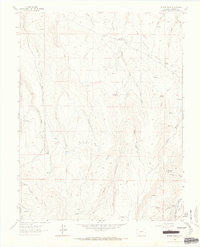
1963 Map of Poison Draw
USGS Topo · Published 1966About this map
Gunnison River waters flow through the southeastern corner of this high-country landscape, where the terrain is defined by deep drainage systems like Poison Draw and Cardwell Draw. Surveyed in the early 1960s, this area of Gunnison County reveals a network of natural water sources vital for high-altitude ranching and wildlife, including Armitage Springs, Addington Springs, and Cutler Spring. The presence of an Old RR Grade near the river suggests the importance of early rail transport in navigating this complex topography. To the southwest, the boundary of the Uncompahgre Nat For marks the transition into protected public lands. The map details an intricate web of seasonal watercourses such as Little Blue Creek, Pine Creek, and Willow Creek, which carve through the elevated Mesa lands, while remote Jeep Trails provide the primary means of overland access across the divide.
Find a feature on this map
26 named features on this map. Tap any name to fly to it.
Don’t see what you’re looking for? This feature index may not catch every label — zoom into the map to look around manually.
Map Details
Editions of this 1963 Poison Draw Map
4 editions found
Other maps of this area

1903 · Lake City
USGS Topo · 1:62,500

1905 · Lake City
USGS Topo · 1:62,500

1908 · Uncompahgre
USGS Topo · 1:125,000

1911 · Uncompahgre
USGS Topo · 1:125,000

1954 · Cebolla
USGS Topo · 1:24,000

1954 · Sapinero
USGS Topo · 1:24,000

1954 · Gateview
USGS Topo · 1:24,000

1956 · Curecanti Needle
USGS Topo · 1:24,000

1956 · Montrose
USGS Topo · 1:250,000

1959 · Montrose
USGS Topo · 1:250,000