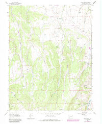
1963 Map of Poison Draw
USGS Topo · Published 1984About this map
Cow Creek Mesa dominates this high-country landscape in Gunnison County, where a network of deeply incised drainages like Poison Draw and Cardwell Draw carve through the terrain. The map captures a transition in land use, showing a primitive Landing Strip and various Jeep Trails that provide access to this isolated area. Water is the primary driver of the map's geography, with the Gunnison River appearing in the southeast corner while numerous named springs, such as Addington Springs and Armitage Springs, serve as critical landmarks for local land management. The drainage pattern is complex, featuring the Little Blue Creek and several forks of Willow Creek, including Dry Willow Creek. A network of fine dashed lines denotes local fence lines, indicating the area's history of ranching and livestock grazing.
Find a feature on this map
30 named features on this map. Tap any name to fly to it.
Don’t see what you’re looking for? This feature index may not catch every label — zoom into the map to look around manually.
Map Details
Editions of this 1963 Poison Draw Map
4 editions found
Other maps of this area

1903 · Lake City
USGS Topo · 1:62,500

1905 · Lake City
USGS Topo · 1:62,500

1908 · Uncompahgre
USGS Topo · 1:125,000

1911 · Uncompahgre
USGS Topo · 1:125,000

1954 · Cebolla
USGS Topo · 1:24,000

1954 · Sapinero
USGS Topo · 1:24,000

1954 · Gateview
USGS Topo · 1:24,000

1956 · Curecanti Needle
USGS Topo · 1:24,000

1956 · Montrose
USGS Topo · 1:250,000

1959 · Montrose
USGS Topo · 1:250,000