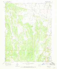
1963 Map of Poison Draw
USGS Topo · Published 1971About this map
Uncompahgre Nat For defines the western edge of this rugged Colorado territory, where a network of ephemeral watercourses and deep-cut draws carve through the high mesa. Surveyed in the early 1960s, the landscape is defined by its drainage patterns, with Poison Draw, Cardwell Draw, and Sandy Draw channeling toward the southern reaches. Near the southeastern corner, the Gunnison River flows past an Old RR Grade, signaling the historic transportation corridor that once followed the river's path. Numerous isolated water sources like Addington Springs, Armitage Springs, and Mahan Spring are documented across the terrain, serving as critical landmarks in an otherwise arid environment of sage and rock. The map captures a moment before modern infrastructure altered these corridors, preserving the location of cattle fences and old trails used by local ranchers and early explorers.
Find a feature on this map
33 named features on this map. Tap any name to fly to it.
Don’t see what you’re looking for? This feature index may not catch every label — zoom into the map to look around manually.
Map Details
Editions of this 1963 Poison Draw Map
4 editions found
Other maps of this area

1903 · Lake City
USGS Topo · 1:62,500

1905 · Lake City
USGS Topo · 1:62,500

1908 · Uncompahgre
USGS Topo · 1:125,000

1911 · Uncompahgre
USGS Topo · 1:125,000

1954 · Cebolla
USGS Topo · 1:24,000

1954 · Sapinero
USGS Topo · 1:24,000

1954 · Gateview
USGS Topo · 1:24,000

1956 · Curecanti Needle
USGS Topo · 1:24,000

1956 · Montrose
USGS Topo · 1:250,000

1959 · Montrose
USGS Topo · 1:250,000