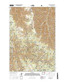
2017 Map of Poison Point
USGS Topo · Published 2017About this map
Wallowa National Forest land defines this corner of northeast Oregon, characterized by a network of high ridges and canyon drainage systems. The landscape is marked by landmarks such as Poison Point and Fairchild Point, while water sources are frequently noted as named springs, including Fairchild Spring, Poison Spring, and Hideaway Spring. These localized water points and the presence of man-made features like Cutout Reservoir and Rice Corral Reservoir suggest a landscape managed for livestock or wildlife within the rugged timberland. The map provides a look at the backcountry infrastructure of the early 21st century, where routes like Buckhorn Rd and Cold Springs Rd serve as the primary conduits through the forest. Significant topographic features such as Big Canyon, Wild Canyon, and Hilton Ridge illustrate the complex drainage patterns feeding into Chesnimnus Cr and Devils Run Cr.
Find a feature on this map
66 named features on this map. Tap any name to fly to it.
Don’t see what you’re looking for? This feature index may not catch every label — zoom into the map to look around manually.
Map Details
Editions of this 2017 Poison Point Map
This is the sole edition of this map. No revisions or reprints were ever made.
Other maps of this area

1954 · Imnaha
USGS Topo · 1:62,500

1955 · Grangeville
USGS Topo · 1:250,000

1957 · Elk Mountain
USGS Topo · 1:62,500

1959 · Grangeville
USGS Topo · 1:250,000

1963 · Deadhorse Ridge
USGS Topo · 1:24,000

1963 · Jim Creek Butte
USGS Topo · 1:24,000

1963 · Wapshilla Creek
USGS Topo · 1:24,000

1963 · Poison Point
USGS Topo · 1:24,000
1967 · Billy Meadows
USGS Topo · 1:24,000
1967 · Teepee Butte
USGS Topo · 1:24,000