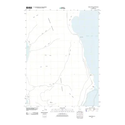
2011 Map of Pokes Point
USGS Topo · Published 2011About this map
The Promontory Mountains dominate this landscape on the northern reaches of the Great Salt Lake, where the high desert meets the salt-rimmed shoreline of Bear River Bay. This 2011 survey reveals a sparsely settled terrain defined by its geology and water sources, including Shaw Spring and Maple Spring. The mountain range is dissected by numerous drainages such as North Canyon, South Canyon, and Cellar Canyon, which feed into the flats of Little Valley and Boothe Valley. Along the coast, the geography is marked by distinctive points and inlets like Pokes Point, Indian Cove, and the restricted passage of The Narrows. Human presence is minimal, anchored by the West Side Ranch and the primary transit artery of S East Promontory Rd, reflecting the remote character of this region of Box Elder County.
Find a feature on this map
25 named features on this map. Tap any name to fly to it.
Don’t see what you’re looking for? This feature index may not catch every label — zoom into the map to look around manually.
Map Details
Editions of this 2011 Pokes Point Map
This is the sole edition of this map. No revisions or reprints were ever made.
Other maps of this area

1954 · Brigham City
USGS Topo · 1:250,000

1955 · Willard Spur
USGS Topo · 1:24,000

1955 · Mouth of Bear River
USGS Topo · 1:24,000

1955 · Fremont Island
USGS Topo · 1:24,000

1958 · Brigham City
USGS Topo · 1:250,000

1962 · Brigham City
USGS Topo · 1:250,000

1967 · East Promontory
USGS Topo · 1:24,000

1968 · Messix Peak
USGS Topo · 1:24,000

1968 · Indian Cove
USGS Topo · 1:24,000

1968 · Pokes Point
USGS Topo · 1:24,000