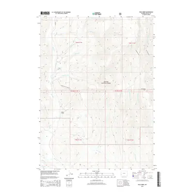
2015 Map of Pole Creek
USGS Topo · Published 2015About this map
Bridger National Forest defines this high-elevation section of Lincoln County, characterized by a complex network of mountain drainages and steep ridges. The terrain is divided by Commissary Ridge and South Fontenelle, where the headwaters of numerous creeks begin their descent. Water is the primary geographic feature, with the main stem of Hams Fork and its tributaries, such as Burke Creek and Elk Creek, carving out the landscape. Evidence of historical resource management and backcountry access is visible through the Poison Hollow Connector and several specifically named drainages like Sawmill Creek and Shingle Mill Creek, which point to the timber history of the region. The map also traces the winding paths of Pole Creek and Carl Creek as they traverse the southern townships.
Find a feature on this map
30 named features on this map. Tap any name to fly to it.
Don’t see what you’re looking for? This feature index may not catch every label — zoom into the map to look around manually.
Map Details
Editions of this 2015 Pole Creek Map
This is the sole edition of this map. No revisions or reprints were ever made.
Other maps of this area

1936 · Cokeville
USGS Topo · 1:96,000

1942 · Cokeville
USGS Topo · 1:125,000

1955 · Preston
USGS Topo · 1:250,000

1958 · Preston
USGS Topo · 1:250,000

1962 · Preston
USGS Topo · 1:250,000
1967 · Pole Creek
USGS Topo · 1:24,000

1967 · Devils Hole Creek
USGS Topo · 1:24,000

1967 · Big Park
USGS Topo · 1:24,000
1967 · Wilkinson Creek
USGS Topo · 1:24,000
1967 · Sublette Canyon
USGS Topo · 1:24,000