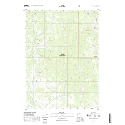
2018 Map of Pole Creek
USGS Topo · Published 2018About this map
Bridger National Forest dominates this high-country landscape in Lincoln County, where the topography is defined by the prominent North-South spine of Commissary Ridge. The area serves as a critical headwaters region, with numerous drainages like Hams Fork, Pole Cr, and Shingle Mill Cr carving deep through the terrain. The presence of the Poison Hollow Connector and Co Rd 305 indicates the light infrastructure supporting forest management and backcountry access. Local history is etched into the landscape through descriptive place names such as Poison Hollow and family-named water bodies like Burke Cr. The map details the intricate network of the W Fork Beaver Cr and Middle Fork Beaver Cr systems, providing a clear picture of the hydrological patterns within this protected forest during the early 21st century.
Find a feature on this map
33 named features on this map. Tap any name to fly to it.
Don’t see what you’re looking for? This feature index may not catch every label — zoom into the map to look around manually.
Map Details
Editions of this 2018 Pole Creek Map
This is the sole edition of this map. No revisions or reprints were ever made.
Other maps of this area

1936 · Cokeville
USGS Topo · 1:96,000

1942 · Cokeville
USGS Topo · 1:125,000

1955 · Preston
USGS Topo · 1:250,000

1958 · Preston
USGS Topo · 1:250,000

1962 · Preston
USGS Topo · 1:250,000
1967 · Pole Creek
USGS Topo · 1:24,000

1967 · Devils Hole Creek
USGS Topo · 1:24,000

1967 · Big Park
USGS Topo · 1:24,000
1967 · Wilkinson Creek
USGS Topo · 1:24,000
1967 · Sublette Canyon
USGS Topo · 1:24,000