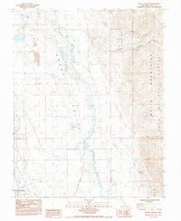
1984 Map of Poleta Canyon
USGS Topo · Published 1984About this map
Owens Valley landscape dynamics are captured here in the mid-1980s, defined by the contrast between the flat alluvial floor and the steep western face of the White Mountains. The meandering course of the Owens River dominates the valley floor, accompanied by numerous Flowing Wells and the small catchment of Saunders Lake. This period of land use is marked by a mix of recreation, infrastructure, and resource extraction, ranging from the Keough Hot Springs in the southwest to the Poleta Mine tucked into the mountain canyons. Transportation routes like Laws Poleta Road and Collins Road provide access to various industrial sites, including a Gravel Pit and several large storage facilities. The presence of the East Line Cem and the Bishop Airport near the western edge reflects the proximity to regional centers of commerce and community memory.
Find a feature on this map
31 named features on this map. Tap any name to fly to it.
Don’t see what you’re looking for? This feature index may not catch every label — zoom into the map to look around manually.
Map Details
Editions of this 1984 Poleta Canyon Map
This is the sole edition of this map. No revisions or reprints were ever made.
Other maps of this area

1913 · Bishop
USGS Topo · 1:125,000

1947 · Mariposa
USGS Topo · 1:250,000

1948 · Mariposa
USGS Topo · 1:250,000

1949 · Bishop
USGS Topo · 1:62,500

1950 · Big Pine
USGS Topo · 1:62,500

1951 · Bishop
USGS Topo · 1:62,500

1951 · Blanco Mountain
USGS Topo · 1:62,500

1951 · Waucoba Mtn.
USGS Topo · 1:62,500

1957 · Mariposa
USGS Topo · 1:250,000
1958 · Waucoba Mtn
USGS Topo · 1:62,500