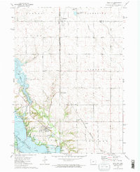
1972 Map of Polk City
USGS Topo · Published 1975About this map
Polk City sits at the heart of a transforming Central Iowa landscape during the early 1970s, where traditional prairie townships meet major water engineering projects. To the south, the Des Moines River valley is dominated by the emergence of Saylorville Lake, with a Barrier Dam Under Constr indicating the massive scale of contemporary flood control and recreation development. This shift is mirrored by the presence of Big Creek Lake to the west. Northward, the map preserves the established agrarian and rail patterns of the region, anchored by the town of Sheldahl and the Chicago and North Western railroad line. Local history is deeply embedded in the land through numerous rural burying grounds, including Slater Cem, Sheldahl Cem, and Lincoln Cem, alongside smaller nodes like Crocker and Polk City Junction that speak to the area's older transportation network.
Find a feature on this map
60 named features on this map. Tap any name to fly to it.
Don’t see what you’re looking for? This feature index may not catch every label — zoom into the map to look around manually.
Map Details
Editions of this 1972 Polk City Map
2 editions found
Other maps of this area

1905 · Des Moines
USGS Topo · 1:62,500

1907 · Des Moines
USGS Topo · 1:62,500

1908 · Waukee
USGS Topo · 1:62,500

1911 · Madrid
USGS Topo · 1:62,500

1911 · Slater
USGS Topo · 1:62,500

1913 · Slater
USGS Topo · 1:62,500

1914 · Madrid
USGS Topo · 1:62,500

1954 · Des Moines
USGS Topo · 1:250,000

1956 · Des Moines
USGS Topo · 1:250,000

1956 · Des Moines NW
USGS Topo · 1:24,000