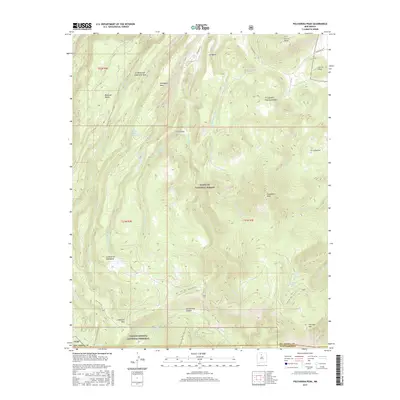
2017 Map of Polvadera Peak
USGS Topo · Published 2017About this map
Polvadera Peak and Chicoma Mtn dominate this high-elevation landscape within the Santa Fe National Forest, where the border of Sandoval and Rio Arriba counties meets the northern edge of the Valles Caldera National Preserve. The terrain is defined by a series of volcanic mesas and deep drainages, including Polvadera Mesa and the notable Santa Clara Canyon. This area serves as a critical watershed, with numerous springs and drainages like Polvadera Creek and Rito de Abiquiu flowing through the high country. Isolated features such as the Road Mesa Trick Tank and high meadows like Cienega Redonda indicate the region's historical use for livestock grazing. The presence of State Hwy 565 and Polvadera Rd provides the primary access through this complex network of volcanic ridges and alpine valleys.
Find a feature on this map
40 named features on this map. Tap any name to fly to it.
Don’t see what you’re looking for? This feature index may not catch every label — zoom into the map to look around manually.
Map Details
Editions of this 2017 Polvadera Peak Map
This is the sole edition of this map. No revisions or reprints were ever made.
Other maps of this area

1890 · Jemes
USGS Topo · 1:125,000

1892 · Jemes
USGS Topo · 1:125,000

1892 · Santa Clara
USGS Topo · 1:125,000

1909 · Gallina
USGS Topo · 1:125,000

1918 · Abiquiu
USGS Topo · 1:125,000

1937 · Jemez Springs
USGS Topo · 1:48,000

1944 · Jemez Springs
USGS Topo · 1:62,500

1952 · Valle Toledo
USGS Topo · 1:24,000

1952 · Jemez Springs
USGS Topo · 1:62,500

1952 · Guaje Mountain
USGS Topo · 1:24,000