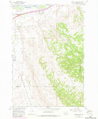
1967 Map of Pompeys Pillar
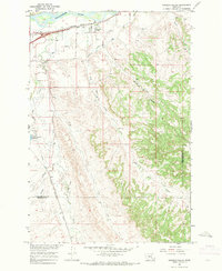
USGS Topo · Published 1980About this map
Yellowstone River flows through the northern reaches of this landscape, a vital corridor defined by early Montana transportation and irrigation. The Northern Pacific railroad tracks parallel the riverbank, connecting the settlement of Pompeys Pillar to the wider region. This area represents a transition from the river valley to the intricate drainages of the southern uplands.
Find a feature on this map
16 named features on this map. Tap any name to fly to it.
Don’t see what you’re looking for? This feature index may not catch every label — zoom into the map to look around manually.
Map Details
Editions of this 1967 Pompeys Pillar Map
2 editions found
Other maps of this area

1893 · Huntley
USGS Topo · 1:125,000

1894 · Fort Custer
USGS Topo · 1:125,000

1954 · Billings
USGS Topo · 1:250,000

1954 · Hardin
USGS Topo · 1:250,000

1954 · Forsyth
USGS Topo · 1:250,000

1954 · Roundup
USGS Topo · 1:250,000

1957 · Hardin
USGS Topo · 1:250,000

1957 · Forsyth
USGS Topo · 1:250,000

1957 · Billings
USGS Topo · 1:250,000

1958 · Billings
USGS Topo · 1:250,000