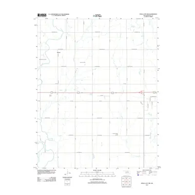
2012 Map of Ponca City NW
USGS Topo · Published 2012About this map
Autwine sits as a central settlement in this portion of Kay County, surrounded by an agricultural landscape defined by a rigid grid of rural section roads like W Prospect Ave and S R St. The area's economic character is visibly tied to the petroleum industry, evidenced by the extensive Autwine Oil Field, the West Autwine Oil Field, and the Southwest Ponca City Oil Field scattered across the township. Natural drainage for these fields is provided by several named tributaries, including Duck Cr, Cowskin Cr, and Bois d'Arc Cr, which all move toward the Salt Fork Arkansas River in the southwestern corner. This survey illustrates the persistent intersection of Oklahoma's prairie farming traditions with its intensive sub-surface mineral extraction at the start of the 2010s.
Find a feature on this map
35 named features on this map. Tap any name to fly to it.
Don’t see what you’re looking for? This feature index may not catch every label — zoom into the map to look around manually.
Map Details
Editions of this 2012 Ponca City NW Map
This is the sole edition of this map. No revisions or reprints were ever made.
Other maps of this area

1955 · Enid
USGS Topo · 1:250,000

1958 · Enid
USGS Topo · 1:250,000

1968 · Tonkawa SE
USGS Topo · 1:24,000

1968 · Marland
USGS Topo · 1:24,000

1968 · Ponca City NW
USGS Topo · 1:24,000

1968 · Ponca City SE
USGS Topo · 1:24,000

1968 · Tonkawa
USGS Topo · 1:24,000

1968 · Kildare
USGS Topo · 1:24,000

1968 · Blackwell
USGS Topo · 1:24,000
1968 · Newkirk SW
USGS Topo · 1:24,000