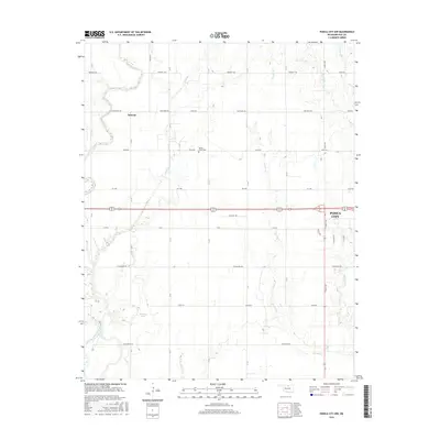
2016 Map of Ponca City NW
USGS Topo · Published 2016About this map
Ponca City and its western outskirts dominate this landscape during a period of modern agricultural and suburban growth. The terrain is defined by the winding course of the Salt Fork Arkansas River in the southwest and a network of creeks, including Duck Cr and Cowskin Cr, that carve through the prairie. In the northwestern section, the settlement of Autwine sits near the intersection of several section roads, representing a persistent community point in the rural Oklahoma landscape. For those interested in local heritage, the Round Grove Cem provides a specific point of genealogical interest centrally located north of Souligny Rd. The map also captures the development around Antwine Lake, reflecting the intersection of local water management and small-scale settlement near the river's edge.
Find a feature on this map
29 named features on this map. Tap any name to fly to it.
Don’t see what you’re looking for? This feature index may not catch every label — zoom into the map to look around manually.
Map Details
Editions of this 2016 Ponca City NW Map
This is the sole edition of this map. No revisions or reprints were ever made.
Other maps of this area

1955 · Enid
USGS Topo · 1:250,000

1958 · Enid
USGS Topo · 1:250,000

1968 · Tonkawa SE
USGS Topo · 1:24,000

1968 · Marland
USGS Topo · 1:24,000

1968 · Ponca City NW
USGS Topo · 1:24,000

1968 · Ponca City SE
USGS Topo · 1:24,000

1968 · Tonkawa
USGS Topo · 1:24,000

1968 · Kildare
USGS Topo · 1:24,000

1968 · Blackwell
USGS Topo · 1:24,000
1968 · Newkirk SW
USGS Topo · 1:24,000