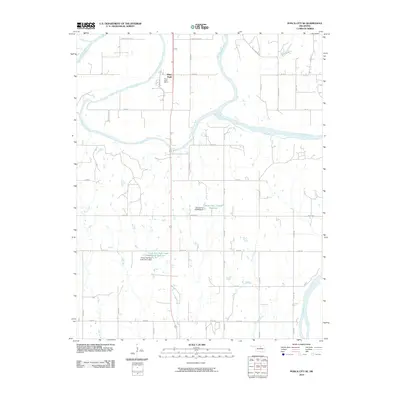
2010 Map of Ponca City SE
USGS Topo · Published 2010About this map
White Eagle and the Ponca Indian Agency anchor this 2010 landscape in Kay County, Oklahoma, situated near the confluence of the Salt Fork Arkansas River and the Arkansas River. This region preserves a unique intersection of tribal administration and agricultural land use patterns along the river valley. The topography is defined by the winding paths of Cowskin Creek and Houston Creek, while human engineering is evident in the water management systems of the Oknoname 103009 Reservoir and the Lower Red Rock Creek Site 3 Reservoir. Local landmarks such as Cowboy Hill and areas identified as Badlands indicate the varied terrain of the southern Ponca City vicinity. A dense grid of rural roads, including White Eagle Dr and Off Eagles Nest, connects the various family homesteads and ranching tracts that characterize this part of the Oklahoma plains.
Find a feature on this map
44 named features on this map. Tap any name to fly to it.
Don’t see what you’re looking for? This feature index may not catch every label — zoom into the map to look around manually.
Map Details
Editions of this 2010 Ponca City SE Map
This is the sole edition of this map. No revisions or reprints were ever made.
Other maps of this area

1930 · Pawnee
USGS Topo · 1:62,500

1936 · Belford
USGS Topo · 1:62,500

1936 · Pawnee
USGS Topo · 1:62,500

1955 · Enid
USGS Topo · 1:250,000

1958 · Enid
USGS Topo · 1:250,000

1963 · Charley Creek
USGS Topo · 1:24,000

1968 · Marland
USGS Topo · 1:24,000

1968 · Ponca City NW
USGS Topo · 1:24,000

1968 · Ponca City SE
USGS Topo · 1:24,000
1968 · Ponca City
USGS Topo · 1:24,000