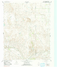
1962 Map of Pond Creek
USGS Topo · Published 1991About this map
The North Fork Red River snakes across the southern portion of this landscape, carving a wide valley that contrasts with the upland ranching country to the north. In the early 1960s, this area of the Texas Panhandle was defined by remote family ranching operations like Webb Ranch, Huseby Ranch, and Harrell Ranch. The presence of Denworth near the riverbanks suggests a small concentration of activity in an otherwise open, working landscape punctuated by vital water sources like White Horse Springs and Tadpole Lake.
Find a feature on this map
18 named features on this map. Tap any name to fly to it.
Don’t see what you’re looking for? This feature index may not catch every label — zoom into the map to look around manually.
Map Details
Editions of this 1962 Pond Creek Map
2 editions found
Other maps of this area

1954 · Amarillo
USGS Topo · 1:250,000

1958 · Amarillo
USGS Topo · 1:250,000

1962 · Hudgens Ranch
USGS Topo · 1:24,000

1962 · Back
USGS Topo · 1:24,000

1962 · Pond Creek
USGS Topo · 1:24,000

1962 · Spring Creek
USGS Topo · 1:24,000

1962 · Pakan
USGS Topo · 1:24,000

1962 · Pond Creek NW
USGS Topo · 1:24,000

1963 · Mobeetie
USGS Topo · 1:24,000

1966 · Laketon
USGS Topo · 1:24,000