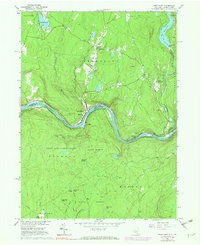
1965 Map of Pond Eddy
USGS Topo · Published 1974About this map
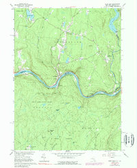
The Delaware River carves a deep, winding path through this 1960s survey, serving as the natural boundary between Sullivan County, New York, and Pike County, Pennsylvania. Along its banks, the Erie-Lackawanna railroad follows the river's bend, connecting small riverside settlements like Pond Eddy and Knights Eddy. To the north, Glen Spey serves as a local hub, while the Rio Reservoir and a nearby powerplant on the Mongaup River highlight the era’s utility infrastructure. Much of the southern terrain is dedicated to State Game Lands No 209 and State Forest land, characterized by high points like Buckhorn Ridge and the Wallowing Hole. Genealogists will find the Sacred Heart Ch and Hillside Cem preserved in the landscape during this period of mid-century development.
Find a feature on this map
47 named features on this map. Tap any name to fly to it.
Don’t see what you’re looking for? This feature index may not catch every label — zoom into the map to look around manually.
Map Details
Editions of this 1965 Pond Eddy Map
5 editions found
Other maps of this area

1906 · Port Jervis
USGS Topo · 1:62,500

1908 · Port Jervis
USGS Topo · 1:62,500

1909 · Monticello
USGS Topo · 1:62,500

1911 · Monticello
USGS Topo · 1:62,500

1913 · Milford
USGS Topo · 1:62,500

1915 · Milford
USGS Topo · 1:62,500

1922 · White Lake
USGS Topo · 1:62,500

1942 · White Lake
USGS Topo · 1:62,500

1942 · Port Jervis North
USGS Topo · 1:24,000
1943 · Port Jervis North
USGS Topo · 1:31,680