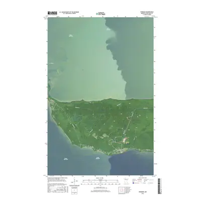
2016 Map of Ponemah
USGS Topo · Published 2016About this map
Upper Red Lake and Lower Red Lake define this unique geographic corridor within the Red Lake Reservation. The settlement of Ponemah occupies the central rising ground of the peninsula, serving as a primary hub for local transportation and community life. The landscape between these two massive bodies of water is marked by a network of reservation roads, including Resvn Hwy 18 and Resvn Hwy 49, which connect the scattered residential pockets and tribal lands.
Find a feature on this map
14 named features on this map. Tap any name to fly to it.
Don’t see what you’re looking for? This feature index may not catch every label — zoom into the map to look around manually.
Map Details
Editions of this 2016 Ponemah Map
This is the sole edition of this map. No revisions or reprints were ever made.
Other maps of this area

1919 · Ponemah
USGS Topo · 1:62,500

1943 · Ponemah
USGS Topo · 1:62,500

1954 · Bemidji
USGS Topo · 1:250,000

1954 · Roseau
USGS Topo · 1:250,000

1957 · Roseau
USGS Topo · 1:250,000

1957 · Bemidji
USGS Topo · 1:250,000

1958 · Bemidji
USGS Topo · 1:250,000

1958 · Roseau
USGS Topo · 1:250,000
1972 · Redby NE
USGS Topo · 1:24,000

1973 · Manomin Creek SE
USGS Topo · 1:24,000