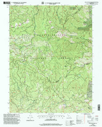
1998 Map of Pony Buck Peak
USGS Topo · Published 2003About this map
Pony Buck Peak anchors this wilderness survey at the convergence of Trinity, Shasta, and Tehama counties. This high-elevation landscape within the Shasta-Trinity National Forests is defined by complex drainage systems, including Beegum Creek and Hayfork Creek, and the presence of small-scale mining activity. Resource extraction history is evident at the Old Bill Mine and Spider Mine, while the remote character of the terrain is highlighted by features like Hell to Find Lake and Regan Meadow. The map documents the primitive road network used for forest management and recreation, notably the Wild Mad Road and several seasonal locations like Goat Camp. Forest Service infrastructure is represented by the Round Mtn No 1 Campsite and Round Mtn No 2 Campsite, showing how this portion of the northern California mountains was used for both industry and backcountry access at the close of the twentieth century.
Find a feature on this map
51 named features on this map. Tap any name to fly to it.
Don’t see what you’re looking for? This feature index may not catch every label — zoom into the map to look around manually.
Map Details
Editions of this 1998 Pony Buck Peak Map
This is the sole edition of this map. No revisions or reprints were ever made.
Other maps of this area

1890 · Red Bluff
USGS Topo · 1:250,000

1894 · Red Bluff
USGS Topo · 1:250,000

1931 · Hoaglin
USGS Topo · 1:96,000

1935 · Hoaglin
USGS Topo · 1:125,000

1951 · Chanchelulla Peak
USGS Topo · 1:62,500

1953 · Blackrock Mtn
USGS Topo · 1:62,500

1954 · Dubakella Mtn
USGS Topo · 1:62,500

1954 · Blackrock Mtn
USGS Topo · 1:62,500

1954 · Yolla Bolly
USGS Topo · 1:62,500

1958 · Redding
USGS Topo · 1:250,000